1. 标题
· Holocene Climate in Arid Central Asia and Timing of Sand Dunes Accumulation in Balikun Basin, Northwest China
· 中国西北地区巴里坤盆地鸣沙山堆积的时间与中亚干旱区全新世气候变化
2. 成果信息
o Junliang J, Wang G, Yang L, Li J, Xu Y, Liu Z. Holocene climate in arid central Asia and timing of sand dunes accumulation in Balikun Basin, Northwest China. Geological Journal. 2019;1–13. https://doi.org/10.1002/gj.3655
3. 成果团队成员
季军良:第四纪地质学博士,地理与信息工程学院副教授,研究方向为新生代地质与环境。
4. 成果介绍
位于哈密西的巴里坤盆地是天山东端的一个山间断陷盆地,盆地南、北和东均为海报超过3500 m的高山,仅西侧山地低缓,海拔约为2000 m。盆地东西长约150 km,西侧宽约70 km,东侧逐渐收窄,宽仅~20 km,地势东高西低,海拔自西向东由约2000 m降至约1570 m,冰雪融水自东向西汇入盆地西端的巴里坤咸水湖。盆地内的年均降水量小于210 mm,但蒸发量可达1600 mm。流水经过区域是盆地内主要的牧场和小麦种植区,在盆地东端茂盛的牧草之上坐落着我国四大鸣沙山之一的巴里坤鸣沙山,犹如绿毯上的明珠。
鸣沙山为什么会形成在这里?什么时间形成的?为了回答这个问题,作者对鸣沙山进行了光释光测年,获得的鸣沙山下部最老的释光年龄约为9 ka。由于该年龄并不是鸣沙山最底部的年龄,为了解决鸣沙山最开始形成的年龄,作者在鸣沙山旁边小河切开的河谷里选择了一个风积剖面,剖面最下部出露河道砂砾石,砂砾石上的风积沙代表了该地区最老的风积物。对该剖面进行了释光测年,获得了风积砂最底部的年龄约为11 ka,也就是鸣沙山开始形成于全新世初期。
在此基础上,对该剖面进行了高分辨率的粒度测量,风力的强度和干旱程度决定了粒度的大小,一般粗粒含量高,代表了干旱的气候。粒度分析结果表明,~6.5 ka之前和~4.3-2.6 ka气候比较干旱,~6.5-4.3 ka气候最湿润,~2.6 ka以来气候较湿润。研究结果与中亚地区前人的研究成果一致,即中亚内陆区在早全新世较干旱,中全新世最为湿润,晚全新世较为湿润,其中~4.3-2.6 ka的极度干旱事件在全球各地均有记录,这一时期也是古代文明更替的重要时期,说明极端气候变化对人类社会的演替有重要影响。
鸣沙山形成的原因包括地貌和气候两个方面。地貌上巴里坤盆地三面高山环绕,仅西侧为低缓山地,且西侧宽阔。来自准噶尔盆地的西北风受天山阻挡,携带砂粒自西向东运移,在天山海拔较低的位置窜出,形成风口,如吐哈盆地的三十里风区、百里风区等著名风口,风口效应进一步加大风力,为风力侵蚀和搬运砂粒提供了更强的动力。巴里坤盆地西侧低缓的山地为风力侵入巴里坤盆地提供了地貌通道,盆地西侧花岗岩体上的蜂窝状风蚀地貌极为发育,当地人称为“怪石山”,是西北风携带砂粒进入巴里坤盆地、打磨花岗岩而成。西北风自巴里坤盆地西侧宽缓低地貌进入盆地,携带砂粒向东运移,由于在盆地东缘受高山阻挡,砂粒在山前堆积形成鸣沙山。气候方面,全新世增温,冰雪消融,大量的松散碎屑物被带入盆地,为风力搬运砂粒提供了大量物源。因此,地形和气候共同造就了巴里坤盆地东端鸣沙山的形成。

图1 巴里坤鸣沙的位置
(A) Landscape of the current study region and locations of previous studies. The black dashed line shows the modern Asian summer monsoon limit (Chen et al., 2008). (1) Balikun Basin (An et al., 2012, 2013; Zhao et al., 2015, 2017), (2) Boston Lake (Huang et al., 2009), (3) Bayanbulak/Yourdusi Basin (Long et al., 2017; Huang et al., 2015), (4) LJW10 loess-paleosol section (Chen et al., 2016), (5) Yili River Valley (Chen et al., 2016), (6) Yili section (Li et al., 2011), (7) Kesang Cave (Cheng et al., 2012; Cai et al., 2017), (8) Sayram Lake (Jiang et al., 2013), (9) Aibi Lake (Wang et al., 2013), and (10) Manas Lake (Rhodes et al., 1996; Wei & Gasse, 1999). (B) Geomorphology of the intermountain Balikun Basin. Note that the only low-elevation landscape (~2,000 m) is present along the northwestern margin of the basin and forms a natural wind gap that enhances the prevailing near-surface wind intensity.
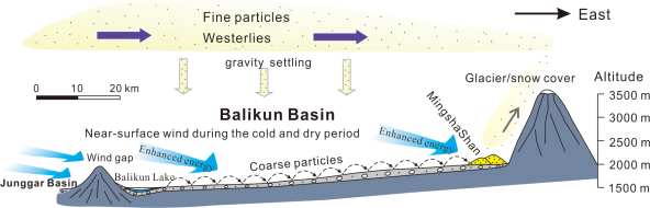
图2 鸣沙山形成示意图
Conceptual model of the aeolian processes and formation of Mingsha Shan in the eastern Balikun Basin. More fine particles were transported by the westerlies during the wet periods, with weak near-surface winds settling the sediments across the Balikun Basin. Conversely, more coarse particles were transported by strong near-surface winds during the cold and dry periods, with deposition across the basin. The only low-elevation gap in the northwest strongly enhanced the near-surface wind intensity when the wind currents entered the Balikun Basin. The dashed arrows show the near-surface transportation of well-sorted coarse particles, and the gray arrow shows the lifted fine particles. More geomorphological details of the Balikun Basin refer to Figure 1B.
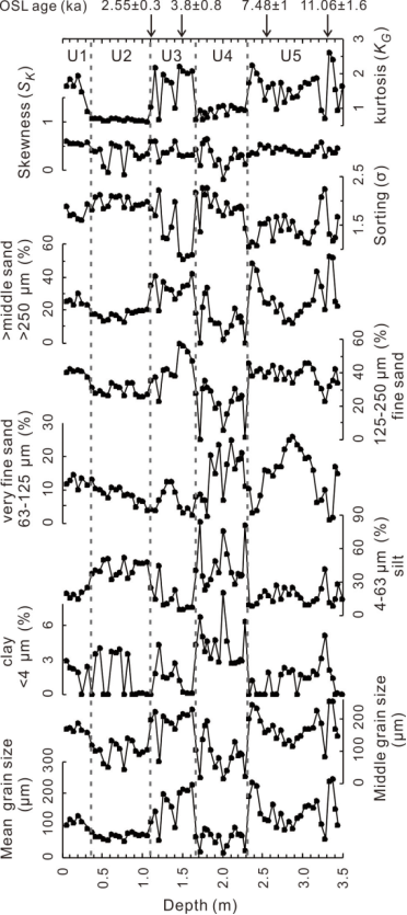
图3 巴里坤盆地鸣沙山剖面粒度曲线与中亚其它地区气候指标的对比。
Comparison of multiproxy records of the Holocene climate in the ACA and EASM regions. (A, B) The two grain-size intervals with the highest variability along the PM103 section in the eastern Balikun Basin. Moisture reconstructions based on (C) pollen records from Balikun Lake (An et al., 2012) and (D) Swan Lake in Yourdusi Basin (the y-axis is the log scale) (Huang et al., 2015), (E) sand-paleosol sequences from the Bayanbulak Basin (Long et al., 2017), (F, G) synthetic records in the Xinjiang region (Ran & Feng, 2013; Wang et al., 2013), and (H) χARM/SIRM of the LJW10 loess-paleosol section on the northern slope of the Tian Shan Range (Chen et al., 2016). (I) Pollen-based precipitation in the north-central EASM region (Chen et al., 2015).